Master planning, as well as component plans i.e. habitat restoration plans, habitat conservation plans, sustainability plans, market and marketing strategies,etc.
 Planning projects Hoʻokuleana LLC have been involved in, include:
ʻĀina Mauna Legacy Program – Preparation of Master Plan and Implementation Work Plan
The ʻĀina Mauna Legacy Program is DHHL’s long‐range planning document geared to restore and protect approximately 56,000‐acres of native Hawaiian forest on Mauna Kea that is ecologically, culturally and economically self‐sustaining for the Hawaiian Home Lands Trust, its beneficiaries and the community.
ʻĀina Mauna Legacy Program – Cultural Impact Assessment (CIA)
As part of the Environmental Assessment preparation process, a separate Cultural Impact Assessment was prepared for the ʻĀina Mauna Legacy Program. The scope of work for the Cultural Impact Assessment included examination of cultural and historical resources, with the specific purpose of identifying traditional Hawaiian activities as may be indicated in the historic or oral history records; a review of previous archaeological work and the identification and description of cultural resources, practices, and beliefs associated with ʻĀina Mauna; and consultation and interviews with knowledgeable parties regarding traditional cultural practices, present and/or past uses of the area.
Waikīkī – Kauhale O Hoʻokipa Scenic Byway – Preparation of Nomination, Application and Scenic Byway Corridor Management Plan
 Waikīkī – Kauhale O Hoʻokipa Scenic Byway runs through the core of Waikīkī. Literally, ‘Waikīkī – Kauhale O Hoʻokipa’ translates to ‘Waikīkī – Home of Hospitality.’ But, this context of “Home” can expand and also represent the community of Waikīkī. Through the telling of stories of Waikīkī (and a goal of the establishment of a Scenic Byway (and dream of NaHHA founder, George Kanahele,)) we help to restore Hawaiianness to Waikīkī in a positive, productive and respectful way. The sense of place of Waikīkī lies within these stories, under the overarching contexts of “Aloha” and “Hoʻokipa” (Hospitality.)
Holo Holo Kōloa Scenic Byway – Preparation of Scenic Byway Corridor Management Plan
 Holo Holo Kōloa Scenic Byway is situated on the South Shore of the island of Kauaʻi in the State of Hawaiʻi (in the historic Old Kōloa Town, running down and through the Poʻipū Beach resort area.) The focus of interest along the Holo Holo Kōloa corridor is the region‘s history and the role this area played in helping to shape Hawaiʻi‘s socio-economic past, present and future. As noted in the book The Kauaʻi Album, “The history of Kōloa is in many ways Hawai‘i’s history in microcosm.” The Holo Holo Kōloa Corridor Management Plan (CMP) is a guide to call attention to and protect the area’s significant historic, archaeological, cultural, natural, scenic and recreational resources.
 Royal Footsteps Along the Kona Coast – Preparation of Scenic Byway Corridor Management Plan
The Royal Footsteps Along The Kona Coast was designated as the state’s second Hawaiʻi Scenic Byway, completing a voluntary, cooperative effort to define a vision for the future of this significant, historic roadway and its surrounding landscape. The designated corridor extends the entire length of Aliʻi Drive, encompassing numerous places and sites that retain archaeological, historic and cultural importance.
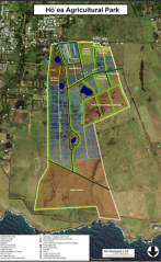
Hōʻea Agricultural Park – Preparation of Master Plan and Management Strategy
 Hōʻea Agricultural Park is a private agricultural park situated at Upolu Point in North Kohala. The vision of the Hōʻea Agricultural Park Plan is the development and management of the agricultural park as a diversified, collaborative, sustainable system, that provides land access and farming opportunities for multiple small farmers whose production, marketing and education activities support local food availability, that is economically viable, environmentally sound and provides value for all participants – the North Kohala community, farmers, collaborators and Hawaiʻi County residents.